SAGAR ISLAND, India — Mohan Das always scores a generous catch the day before a cyclone. When the wind howls and lightning strikes, birds migrate inland to shelter among mangroves. The waves rise increasingly higher until the water finally gushes through the swampy shore, destroying everything in its wake.
“You always know when it’s coming,” the local fisherman says on a hot day in October, untangling his fingers from a large fishing net as fish fall at his feet, flopping on the ground.
Das, who is short and sturdy, walks briskly in a bright red flannel shirt as he carries his fishing equipment in one hand. The 31-year-old has just returned from an early morning fishing trip off the coast of Sagar Island. It is a small, teardrop-shaped island in the Sundarbans, a fragile ecosystem that consists of 200 islands spread over 40,000 hectares in India and Bangladesh. This is the world’s largest delta, formed by the confluence of the rivers Ganges, Brahmaputra and Meghna as they flow into the Bay of Bengal. But the traditional life in the Sundarbans is now barely surviving due to rampant deforestation, land use and global warming.
India has never been immune to extreme weather events—in the past 30 years, it has been hit by some 300 natural disasters, according to the natural disaster database EM-DAT. In the months of April and May, as well as October and November, heavy storms sweep across the country. The Groundswell Report by the World Bank Group estimates that without any concrete climate action, over 40 million people will be forced to migrate internally by 2050 to escape the slow onset impacts of climate change. And the delta between India and Bangladesh is set to become an epicenter of climate-induced migration as residents are forced to flee their homes in the coming decades, trapped between rising sea levels and the crumbling economy.
Many countries made pledges at the COP-26 climate change conference in Glasgow this year. India committed to reaching net-zero emissions by 2070, but that will do nothing to help the Sundarbans. Over the past three decades, thirteen of the world’s 23 most devastating cyclones have struck the islands, destroying the lives and livelihoods of its nearly 4.6 million inhabitants. Local residents like Das are used to rebuilding their homes after every cyclone, with the threat of displacement constantly looming. These islands are sinking fast—by 2050, they will be completely flooded, according to a 2019 report by the environmental non-profit Climate Central. Das, who has worked as a fisherman his entire life, already contends with the effects every day.
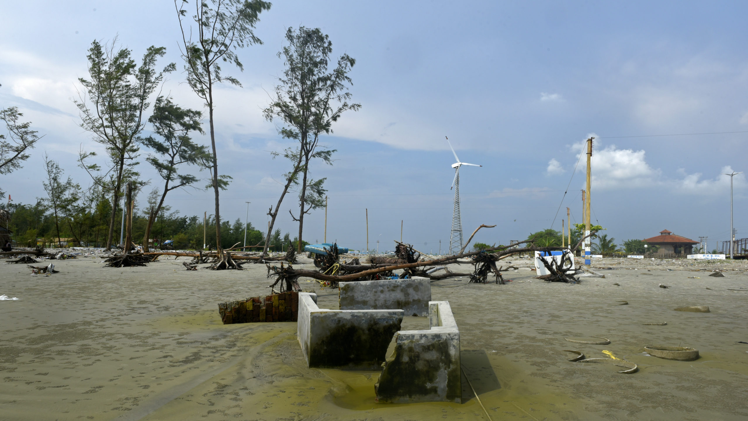
“Everything is slowly vanishing into the water,” he says, pointing to two large cement blocks submerged near the bright sandy beach. They are the sparse ruins of what was once his fishing shed, now completely destroyed by Cyclone Yaas earlier this year.
The Sundarbans are located at the southernmost tip of West Bengal, 80 miles south of the state’s capital city, Kolkata. Home to one of the world’s largest mangrove forests, it was declared a UNESCO World Heritage Site in 1987. Although deforestation decreased after it was given protected status, sea erosion has slowly turned the fertile soil into brackish swampland.
Sagar is the largest island in the continental shelf. It is densely populated with over 200,000 inhabitants who live in small, scattered villages among lush green palm trees. The island is known for hosting the Gangasagar Mela, a Hindu pilgrimage festival that attracts millions of devotees every January. Local tourists and residents visit the beach to see the colorful, three-spired Kapil Muni Temple devoted to Lord Vishnu, taking dips in the holy water of the River Ganges as it flows into the sea.
But even the gods aren’t safe on Sagar. The temple has been moved and rebuilt four times after it was destroyed by coastal erosion. Each time, the structure has moved further from where it once stood on the coast.
Climate change has struck Sagar Island more swiftly in the last two years: In May, as India struggled to deal with a second Covid-19 outbreak, Yaas lashed coastal areas with heavy wind and rain, intensifying into a what was classified as a very severe cyclonic storm that destroyed some 20,000 homes and forced the evacuation of more than a million people. Before Yaas, three more cyclones had already wreaked havoc in 2019 and 2020. During this time, Sagar has shrunk by about 20 square miles.
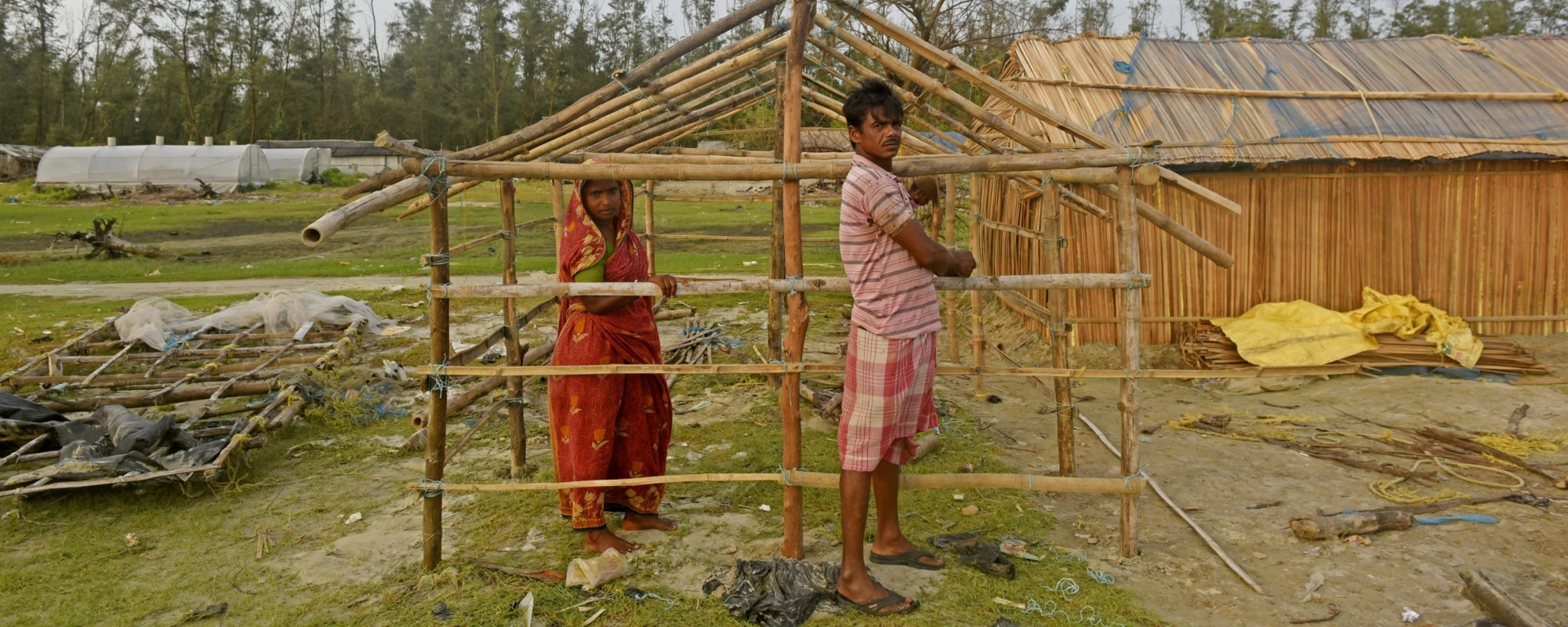
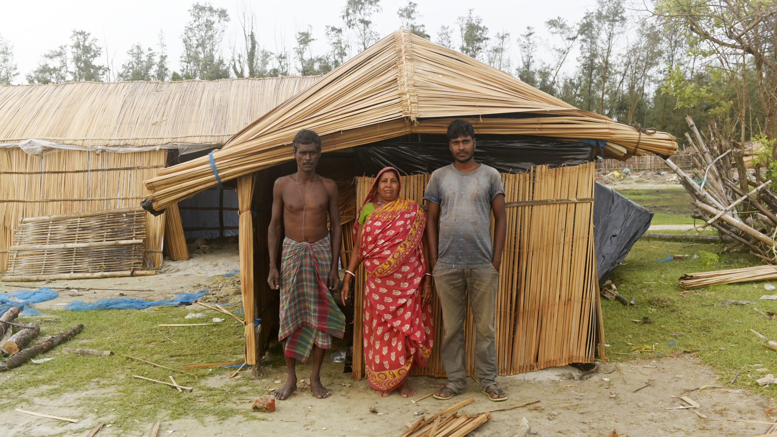
For the island’s residents, climate migration is already a lived reality. Along the Gangasagar beach, families are busy constructing thatched roofs for temporary sheds, where they will live for the next six months during the fishing season. During cyclone season, most evacuate their homes in the nearby Bishnupur village and move to a relief shelter set up by the local district, before returning, rebuilding and then moving to their fishing sheds.
Protima Mondal, who lives on the island with her husband and son, clearly remembers the day she evacuated her home during Yaas. As sea water slowly encroached on the family’s home and began to flood every room, the 45-year-old fisherman’s wife scooped up her 2-year-old grandson and fled. The Mondals took only their land property documents and personal identification cards to the relief center, leaving behind all other personal belongings to be swept away by the water. The family stayed at the shelter for a month, surviving on two meals a day. They lost the equivalent of nearly $3,000 worth of fishing materials, almost all of their yearly savings, and received very little compensation from the state. But now they are back on the coastline, slowly rebuilding their fishing shed to restart their business.
“Fishing is the only way for our family to survive,” Mondal says, digging into the ground with a wooden plank. Without land for farming or other skills, his only options to make an income are from fishing or manual labor, which pays a meager salary.
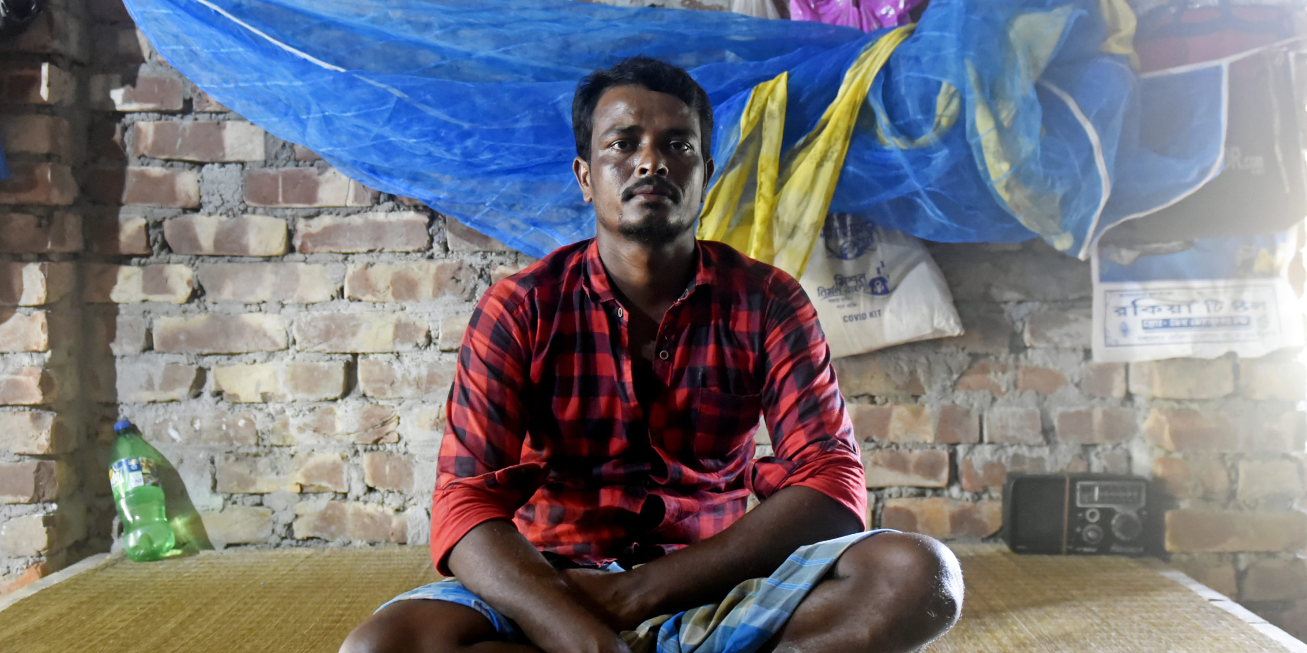
In the grassy patch next to the Mondals, the Pradhan family has also faced similar trials. When Cyclone Amphan came to their doorstep in 2019, the wind was so ferocious that the sand blowing in their faces made it hard to see or breathe. But Yaas was the worst of all the cyclones, says 36-year-old fisherman Sukhdev Pradhan. The water came up to the knees and destroyed the family’s entire house, and all its fishing equipment was lost to the sea. Since then, the family has taken out loans to buy new gear and start again.
Sukhdev’s younger brother Joydeep Pradhan has noticed the water visibly inching closer to the land. He points to small black pipes submerged in the distance, the last remnants of an old well. “That’s where the water used to stop two years ago,” he says.
The dismal future that awaits the island is evident to the family members, who have seen their home destroyed countless times. They know they will have to leave at some point: “The island will probably drown in the next five years,” Sukhdev says in a matter-of-fact tone.
The Pradhans feel helpless. “Nothing is in your hand when a natural disaster strikes,” Joydeep says.
There’s little time to reflect on the inevitability of natural destruction with the fishing season underway, however. The fisherman need to build their huts quickly to mark their territory before the Gangasagar Mela is in full swing in January when thousands of visitors will frolic along the beach. A few months after, the monsoons will again subject the island to floods, tidal surges and cyclonic storms that have increased in intensity over the past 50 years.
Income in the Sundarbans is traditionally also generated from forest work and prawn seed collection. As business dwindled and tourists disappeared during the pandemic, many landowners and migrant laborers returned to fishing and farming in the mangrove delta. But Yaas and heavy monsoon rainfall have also helped turn the farmland infertile, with saline water and rainfall flooding acres of crop.
From a jetty, the neighboring islands look like small blips along the water. Some islands like Lohachhara, Suparibhanga and Bedford have long vanished, preserved only in the memory of a few community elders who resettled in Sagar. Others, like Ghoramara and Mousini, are expected to go underwater within the next six years.
On neighboring Ghoramara Island, unprecedented erosion in the past few years has shrunk the land from 10 square miles to a mere 2.5 square miles. Almost 12 percent of the shoreline has been lost to the advancing sea. NASA satellite images reveal the rise of the sea level by an average of three centimeters a year over the past two decades.
At one point, Ghoramara was inhabited by 40,000 people. Now, only 2,000 remain. As more villagers abandon their homes and relocate elsewhere, there is a palpable sense of desperation. Many are counting their pennies to see how long they can survive, some are selling their chickens and other possessions. After Yaas took a big chunk of the island away, those who lost fertile land and homes and took refuge on Sagar Island now work as seasonal laborers.
In May, Sagar’s local block development officer, state civil servants responsible for the planning and management of local districts, announced that 30 families from Ghoramara Island would be relocated here, with land rights near Bamankhali village. “The entire Ghoramara Island is in a vulnerable situation, but these 30 families are the worst hit for the past two years because of two successive cyclones, Amphan and Yaas,” the officer, Sudipta Mondal, said.
He explained that the local government has been searching for land for such families, but the challenge of finding a long enough stretch to accommodate a whole colony is near-impossible. The need, he said, was not just for relocation, but also support for the families’ livelihoods: “We need a coordinated initiative of land reforms, housing, fisheries, panchayats [district councils], animal husbandry departments,” he said.
The housing department will build huts for the 30 families next year, an initiative officials hope will allow them to resettle well. Along with residential huts, the district administration and fisheries department also plan to dig ponds, build toilets and offer the families free ducks and chicks for rearing.
But there is only so much land to go around. Sagar’s residents feel conflicted about the fate of their own island as the resettlement takes place. “Where will we all go when this island sinks?” Mohan Das asks.
A report published by the World bank in 2014 suggested a “planned retreat” of the population and the regeneration of mangroves in the vacated vulnerable zone as the only long-term strategy. “The community’s wellbeing is getting diminished; the in-situ adaptation modes in the forms of infrastructure like embankments are useless in the long run,” the report states. It suggests phasing out the migration of the population, and gradually integrating residents into the urban areas as the only possible plan.
Along with extreme weather, those living in the delta are also battling poverty from lost income, exacerbated by inaction by state and national governments. Only the strategies around planting more mangroves and building embankments have been implemented. In 2018, a sandbank was built to separate the area of Shivpur, a freshwater canal, from a flat expanse of the beach along the southern coast of the island. Now, the state government is building seawalls. During the cyclone season, it will also evacuate local residents to temporary relief shelters to follow state disaster management policies. But despite the displacement of millions each year, India lacks long-term strategies for managing the migration arising from slow-onset events like coastal erosion and rising sea level. There is no plan for how to supplement local incomes or move residents to urban areas.
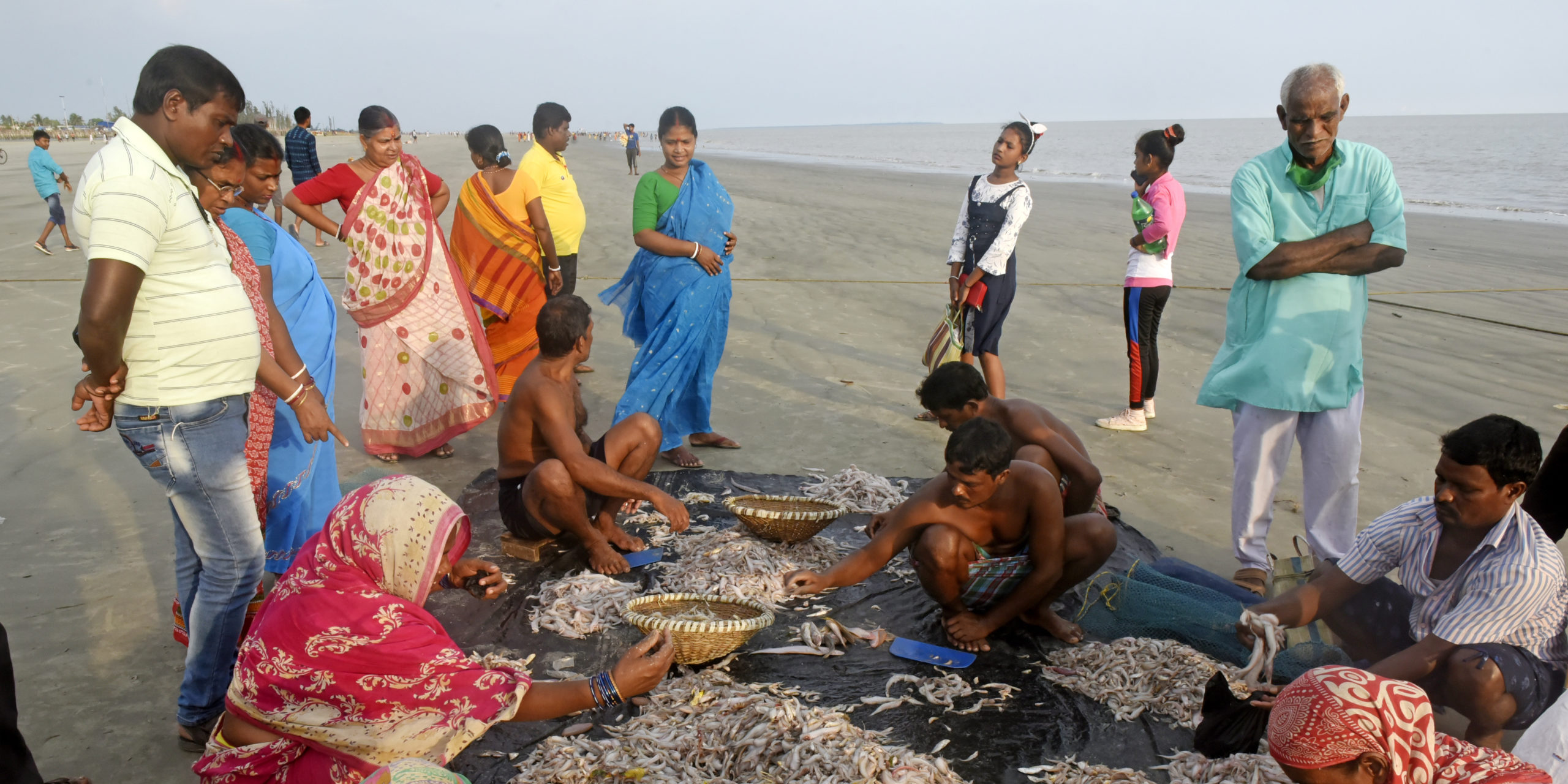
As the saline water penetrates farmland, leaving it unfit for cultivation, more residents are turning to fishing for their livelihoods, an unsustainable measure as their catches are fast dwindling. Mohan Das is selling a sizable catch when I meet him again at dusk. Shrimp, ilish and carp are sprawled across a tarpaulin sheet on the beach, where he has set up a makeshift fish market. Between sales, he looks up and smiles in resignation. “People can eat, it’s a good day for business,” he says. “But who knows how long this will last?”
Top photo: The Mondals build huts to relocate homes for the fishing season on Sagar Island (Indranil Aditya)